Red flag warning in Southern Utah forecasts ‘new wildfire starts’
ST. GEORGE — The National Weather Service in Salt Lake City has issued a red flag warning for dry thunderstorms and gusty outflow winds in portions of central and southwestern Utah.
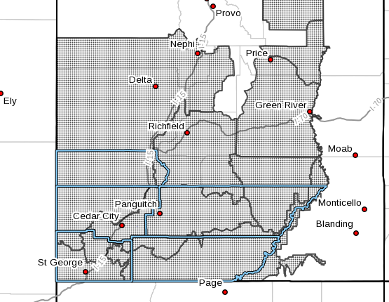
The warning will be in effect Thursday from 10 a.m. to 10 p.m. Affected areas include the entirety of Washington, Iron, Beaver, Garfield and Kane counties, as well as portions of central Utah.
According to the National Weather Service, isolated to scattered dry thunderstorms are forecast to develop late morning through early afternoon, lasting into the evening. Little to no rainfall is expected, and strong winds exceeding 40 mph are possible near the thunderstorm activity.
New wildfire starts due to lightning are expected, and locally strong outflow winds may contribute to rapidly spreading fires.
Precautions and preparedness
If you are traveling or planning to recreate using ATVs or similar vehicles, take the following precautions to avoid starting a wildfire:
- Avoid driving or parking your vehicle in tall grass.
- Never throw a lighted cigarette out of a vehicle.
- When pulling a trailer, attach safety chains securely; loose chains can drag on the pavement and cause sparks, igniting roadside fires.
- Look behind you before driving away from fire-sensitive locations such as areas with tall grass or campsites to check for signs of a developing fire.
- Always use a spark arrester on internal combustion engines.
Read more: ‘If it can spark, it can cause a fire’: Tips on preventing human-caused wildfires
For the most current conditions, warnings and advisories, go to the National Weather Service-Salt Lake City office website. Additional information on driving conditions can be found at the UDOT website, as well as UDOT’s Commuterlink for current road and weather conditions, or dial 511.
Email: news@stgnews.com
Twitter: @STGnews
Copyright St. George News, SaintGeorgeUtah.com LLC, 2019, all rights reserved.