Southern Utah weekend weather: Possible rain in St. George, with snow likely in most other areas
ST. GEORGE— According to the National Weather Service, this weekend’s weather for the majority of southwestern Utah will include rain and snow showers, with snow accumulation reaching up to more than 5 inches in some areas like Brian Head.
Below are your St. George, Cedar City, Zion National Park and Brian Head area weekend weather forecasts, including current warnings and advisories.
And for a look at this weekend’s events, check out the St. George News TGIF Show: Your weekend adventure guide brought to you by Virgin River Casino.
St. George
Friday
Mostly cloudy with a high of 53 and low of 34, with south-southwest winds of 5-9 mph. There’s a chance of showers before noon, with a 40 percent chance of precipitation.
Saturday
Partly sunny with a high of 51 and low of 32, with west-southwest winds of 6 mph. There’s a 30 percent chance of rain showers after noon.
Sunday
Partly sunny with a high of 46 and low of 25, with west-southwest winds of 5-7 mph.
Read more: The ‘2018 Christmas Light Spectacular’ kicks off with the chance to win $300 from HedgeHog Electric
Cedar City
Friday
Cloudy with a high of 41 and low of 21, with west-southwest winds of 5-9 mph. There’s a chance of snow before noon, with a 60 percent chance of precipitation. Total daytime snow accumulation of less than a half inch is possible.
Saturday
Mostly sunny with a high of 38 and low of 21, with southwest winds of 5-9 mph. There’s a 30 percent chance of snow showers after noon. New snow accumulation of less than a half inch is possible.
Sunday
Mostly cloudy with a high of 28 and low of 12, with north winds of 5-7 mph. There’s a 50 percent chance of snow. New snow accumulation of less than a half inch is possible.
Read more: What’s in a name? School committee to decide fate of Cedar High’s ‘Redmen’ mascot
Zion National Park/Springdale
Friday
Cloudy with a high of 43 and low of 22, with southwest winds of 7-13 mph. Rain and snow are likely, with a 70 percent chance of precipitation. Little or no snow accumulation is expected.
Saturday
Cloudy with a high of 41 and low of 24, with southwest winds of 5-8 mph. There’s a 40 percent chance of snow showers after 11 a.m., with new snow accumulation of less than a half inch possible increasing to 1-3 inches in the evening. Chance of precipitation is 80 percent in the evening.
Sunday
Partly sunny with a high of 37 and low of 15, with north-northwest winds of 9-11 mph. There’s a 50 percent chance of snow, with new snow accumulation of less than a half inch possible.
Brian Head
According to the Brian Head Resort website, the area has received 9 inches of snow over the last 24 hours, making for a 31-inch base depth.
Friday
Cloudy with a high of 19 and low of 8, with west-southwest winds of 8-15 mph. Snow showers are likely before 11 a.m. Chance of precipitation is 100 percent, and total snow accumulation of 2-4 inches is possible.
Saturday
Cloudy with a high of 17 and low of 5, with west-southwest winds of 6-14 mph. There’s a 50 percent chance of snow showers, and new snow accumulation of 1-2 inches increasing to 7-11 inches in the evening is possible. Wind chill is valued as low as -12.
Sunday
Cloudy with a high of 8 and low of -1, with north winds of 10 mph. Snow is expected, with new snow accumulation of 1-2 inches possible. Chance of precipitation is 80 percent.
For current snow accumulation totals, weather and lift status at Brian Head Resort, click here.
Weather warnings and advisories
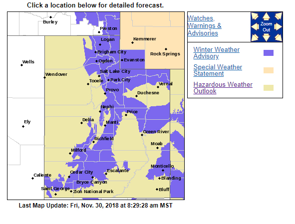
There is a hazardous weather outlook in place for the western two thirds of Utah that will kick in Friday, bringing rain and snow fall to valley floors. Accumulating snow is possible during this time. A colder storm system is expected to impact the region throughout the weekend.
Beginning on Saturday, a cold storm system is expected to impact the region throughout the week, bringing snow to Southern Utah, excluding St. George.
In addition, a winter weather advisory is in place until Friday evening and is impacting southern mountain areas, including Bryce Canyon. Total snow accumulations of 8-16 inches is expected. Winter driving conditions can be expected on mountain routes, including the higher passes of interstate 70 and interstate 15, as well as US-40.
A winter weather advisory for snow means periods of snow will cause primarily travel difficulties. Expect snow covered roads and limited visibilities, and use caution while driving.
For more information on current weather conditions and advisories, go the National Weather Service-Salt Lake City office website. For winter road conditions, go to the Utah Department of Transportation website.
Email: mheckenliable@stgnews.com
Twitter: @STGnews | @markeekaenews
Copyright St. George News, SaintGeorgeUtah.com LLC, 2018, all rights reserved.