Southern Utah weekend weather: Great time to stay indoors as rain, snow, high winds are expected
ST. GEORGE — According to the National Weather Service, this weekend’s weather for the majority of southwestern Utah will include mostly cloudy skies, with rain and snow for most areas. Due to heavy rainfall, officials are urging people to use caution near slot canyons and rivers. In addition, extremely high winds are expected in most areas.
Below are your St. George, Cedar City, Zion National Park and Brian Head area weekend weather forecasts, including current warnings and advisories. And for a look at this weekend’s events, check out the St. George News TGIF Show: Your weekend adventure guide brought to you by Virgin River Casino.
St. George
Friday
Sunny with a high of 63 and low of 45, with east winds of 5-8 mph.
Saturday
Cloudy with a high of 57 and low of 43, with southeast winds of 10-15 mph. There’s a 90 percent chance of rain.
Sunday
Mostly cloudy with a high of 52 and low of 41, with southwest winds of 13-20 mph. There’s a 60 percent chance of rain, mainly before 11 a.m.
Read more: 3rd annual jazz festival to feature prominent trombonist, Canadian singer
Cedar City
Friday
Sunny with a high of 50 and low of 34, with south winds of 6-11 mph.
Saturday – high winds
Cloudy with a high of 50 and low of 34, with south winds of 14-23 mph and gusts as high as 45 mph in the evening. There’s a 80 percent chance of rain.
Sunday – high winds
Cloudy with a high of 40 and low of 33, with south-southwest winds of 18-28 mph and gusts as high as 41 mph. Rain and snow are likely before 11 a.m., with a 70 percent chance of precipitation. New snow accumulation of 1-2 inches is possible.
Read more: SUU dance concert ‘Public Displays’ to include choreography from Burch Mann’s American Folk Ballet
Zion National Park/Springdale
Friday
Sunny with a high of 52 and low of 34, with east-northeast winds of 8-11 mph. There’s a 20 percent chance of rain in the evening.
Saturday – high winds
Cloudy with a high of 48 and low of 33, with east-southeast winds of 15-22 mph. Winds are expected to increase to 32-37 mph in the evening, with winds gusts up to 55 mph. There’s a 90 percent chance of rain.
Sunday – high winds
Mostly cloudy with a high of 44 and low of 30, with southwest winds of 29-34 mph and winds gusts as high as 48 mph. There’s a 80 percent chance of rain and snow, mainly before noon. Little to no snow accumulation is expected.
Brian Head
According to the Brian Head Resort website, the area has received 0 inch of snow over the last 24 hours, maintaining a 48-inch base depth.
Friday – high winds
Sunny with a high of 33 and low of 24, with south winds of 14-22 mph. Winds are expected to increase to 31-36 mph in the evening, with wind gusts as high as 55 mph. There’s a 40 percent chance of snow in the evening. New snow accumulation of less than a half inch possible.
Saturday – high winds
Cloudy with a high of 29 and low of 22, with south winds of 37-43 mph and gusts as high as 60 mph. There’s a 100 percent chance of snow, with new snow accumulation of 1-3 inches possible.
Sunday – high winds
Cloudy with a high of 24 and low of 22, with south winds of 37-43 mph and gusts as high as 60 mph. There’s a 100 percent chance of snow. New snow accumulation of 1-3 inches possible.
For current snow accumulation totals, weather and lift status at Brian Head Resort, click here.
Weather warnings and advisories
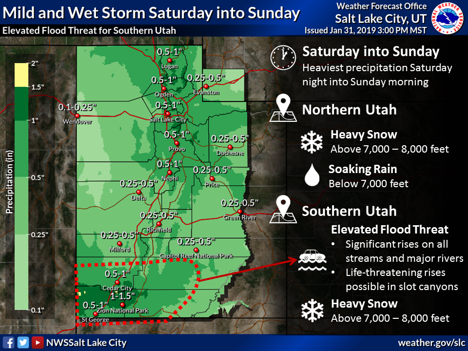
A hazardous weather outlook is in place for the western two thirds of Utah. A warm system will bring heavy rainfall to Southern Utah. Valley rain and mid-high mountain snow can be expected across northern Utah.
With the heavy rainfall across Southern Utah this weekend, area rivers will be running high. Slot canyons and small streams are expected to be running high and fast. Those with outdoor plans in these areas are urged to monitor forecasts over the next several days. Valley snow is expected with a colder storm Monday night into Wednesday morning. Significant snow accumulations are possible for much of the area.
For more information on current weather conditions and advisories, go the National Weather Service-Salt Lake City office website. For winter road conditions, go to the Utah Department of Transportation website.
Email: mheckenliable@stgnews.com
Twitter: @STGnews | @markeekaenews
Copyright St. George News, SaintGeorgeUtah.com LLC, 2019, all rights reserved.