Southern Utah weekend weather: Winter road conditions for some and smooth sailing for others
ST. GEORGE — According to the National Weather Service, this weekend’s weather for the majority of southwestern Utah will bring possible snow and rain to some smaller cities on Friday and higher temperatures to most areas through the rest of the weekend. However, a hazardous weather outlook is forecasting a return of precipitation at the beginning of the next week.
Below are your St. George, Cedar City, Zion National Park and Brian Head area weekend weather forecasts, including current warnings and advisories. And for a look at this weekend’s events, check out the St. George News TGIF Show: Your weekend adventure guide brought to you by Virgin River Casino.
St. George
Friday
Mostly sunny with a high of 53 and low of 33, with west winds of 5-7 mph.
Saturday
Sunny with a high of 55 and low of 36, with northeast winds of 5-7 mph.
Sunday
Mostly sunny with a high of 57 and low of 36, with east winds of 6 mph. There’s a 20 percent chance of rain after 11 p.m.
Read more: St. George Police search for man who tried to lure young girls into car
Cedar City
Friday
Mostly cloudy with a high of 40 and low of 21, with north winds of 11 mph. There’s a 20 percent chance of snow showers before 11 a.m.
Saturday
Mostly sunny with a high of 46 and low of 28, with north-northeast winds of 6-8 mph.
Sunday
Mostly sunny with a high of 46 and low of 29, with south winds of 8-10 mph. There’s a 30 percent chance of rain and snow after 11 p.m., with new snow accumulation of less than a half inch possible.
Read more: SUU to organize trip to Zion National Park to help with cleanup; all community members invited
Zion National Park/Springdale
Friday
Mostly cloudy with a high of 45 and low of 22, with north winds of 9-15 mph. There’s a 20 percent chance of snow showers before 11 a.m.
Saturday
Sunny with a high of 49 and low of 27, with northeast winds of 7-11 mph.
Sunday
Mostly sunny with a high of 48 and low of 29, with south-southeast winds of 11 mph. There’s a 20 percent chance of rain after 11 p.m.
Read more: Surviving the shutdown; How Zion and its park rangers are making do
Brian Head
According to the Brian Head Resort website, the area has received 1 inch of snow over the last 24 hours, making a 41-inch base depth.
Friday – high winds
Cloudy with a high of 17 and low of 5, with north-northeast winds of 23-33 mph and gusts as high as 47 mph. There’s a 50 percent chance of snow showers before 11 a.m., with total daytime snow accumulation of less than a half inch possible. Wind chill values as low as -8.
Saturday
Mostly sunny with a high of 32 and low of 21, with north winds of 21 mph.
Sunday – high winds
Mostly sunny with a high of 34 and low of 14, with south-southeast winds of 20-26 mph and gusts as high as 40 mph. There’s a 40 percent chance of snow after 11 p.m.
For current snow accumulation totals, weather and lift status at Brian Head Resort, click here.
Weather warnings and advisories
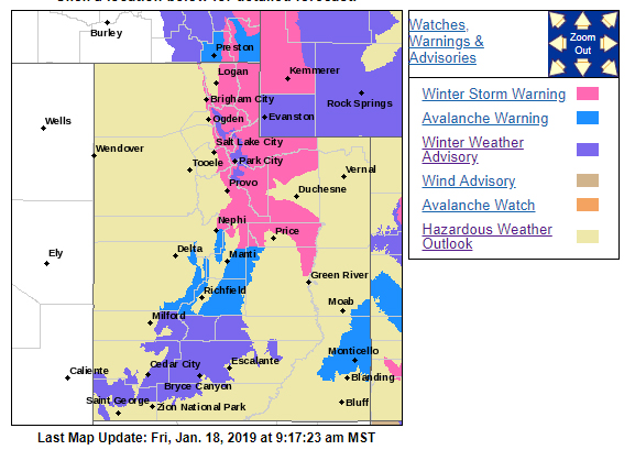
There’s a hazardous weather outlook for the western two thirds of Utah for the areas of Utah’s Dixie, Zion National Park, Glen Canyon Recreation Area, Lake Powell and Southern Utah mountains.
A storm system moving through Utah will maintain occasional rain and snow showers Friday morning. These showers will gradually taper off this afternoon as the storm system exits off to the east.
High pressure positioned across the interior west will bring a break in precipitation to much of the outlook area this weekend. The next storm will bring another round of snow and colder temperatures to much of the outlook area to begin the new week.
Heavy snow is once again expected across Utah’s mountains, with the southern and central mountains likely to see the greater amounts of new snow. Colder temperatures and along with a chance of light snow will settle into the outlook area for the middle of the week.
In addition, there’s a winter weather advisory in effect until 11 a.m. Friday for the cities of Cove Fort, Koosharem, Fish Lake, Loa, Panguitch and Bryce Canyon. Snow accumulations of 1-3 inches is expected. People should plan for slippery and snow-packed road conditions.
For more information on current weather conditions and advisories, go the National Weather Service-Salt Lake City office website. For winter road conditions, go to the Utah Department of Transportation website.
Email: mheckenliable@stgnews.com
Twitter: @STGnews | @markeekaenews
Copyright St. George News, SaintGeorgeUtah.com LLC, 2019, all rights reserved.