Southern Utah weekend weather: Partly sunny skies with slight chance of those April showers
ST. GEORGE — According to the National Weather Service, this weekend’s weather for the majority of southwestern will include partly sunny skies, with a slight chance of rain for most areas.
Below are your St. George, Cedar City, Zion National Park and Brian Head area weekend weather forecasts, including current warnings and advisories. And for a look at this weekend’s events, check out the St. George News TGIF Show: Your weekend adventure guide brought to you by Virgin River Casino.
St. George
Friday
Partly sunny with a high of 69 and low of 48, with southwest winds of 5-7 mph.
Saturday
Mostly sunny with a high of 70 and low of 47, with west winds of 5-7 mph.
Sunday
Sunny with a high of 78 and low of 52, with calm winds.
Read more: Protesters in downtown St. George demand release of Mueller report
Cedar City
Friday
Partly sunny with a high of 57 and low of 39, with south-southwest winds of 8-13 mph. There’s a 70 percent chance of rain after midnight.
Saturday
Mostly cloudy with a high of 57 and low of 37, with west-northwest winds of 5-8 mph. There’s a 60 percent chance of rain.
Sunday
Sunny with a high of 65 and low of 42, with west-northwest winds of 6 mph.
Read more: Intermountain Healthcare donates $60,000 for diversity scholarships for SUU nursing students
Zion National Park/Springdale
Friday
Partly sunny with a high of 60 and low of 36, with south-southwest winds of 5-10 mph. There’s a 20 percent chance of rain after noon.
Saturday
Mostly sunny with a high of 61 and low of 34, with south-southwest winds of 6-10 mph. There’s a 20 percent chance of rain after 9 a.m.
Sunday
Sunny with a high of 69 and low of 38, with north winds of 6-8 mph.
Read more: Biologists confirm California condor nest in Zion National Park
Brian Head
According to the Brian Head Resort website, the area has received 0 inches of snow over the last 24 hours, maintaining a 86-inch base depth.
Friday
Partly sunny with a high of 33 and low of 22, with west-southwest winds of 10-14 mph. There’s a 20 percent chance of snow after noon.
Saturday
Mostly cloudy with a high of 33 and low of 22, with west-southwest winds of 10-14 mph. There’s a 60 percent chance of snow showers, mainly before 9 a.m. New snow accumulation of less than a half inch is possible.
Sunday
Mostly sunny with a high of 41 and low of 28, with west-northwest winds of 7-11 mph.
Weather warnings and advisories
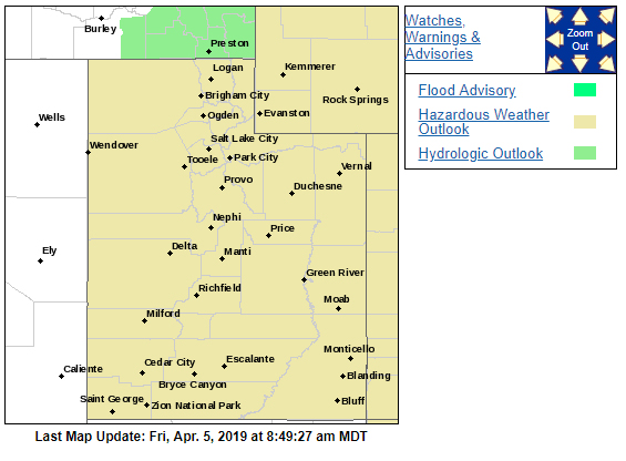
A hazardous weather outlook is in place for the majority of Utah, with the main focus being in northern Utah,; however the outlook does include the following areas: Utah’s Dixie, Zion National Park, Glen Canyon Recreation Area, Lake Powell and Southern Utah mountains.
Accumulating mountain snow is expected across northern Utah late Friday into Saturday morning with snow levels falling from 8000 feet late Friday to 7000 feet early Saturday. Overall mountain snow accumulations are expected to remain below advisory criteria – 6 inches in 12 hours – however there is a 50 percent chance of the Cottonwood Canyons seeing 6 inches or more of snow.
A colder storm system late Tuesday into Wednesday may produce significant accumulating mountain snow across northern Utah, with heavy, wet snow possible to the valley floors of northern Utah.
For the most current conditions, warnings and advisories, go to the National Weather Service-Salt Lake City office website.
Email: mheckenliable@stgnews.com
Twitter: @STGnews | @markeekaenews
Copyright St. George News, SaintGeorgeUtah.com LLC, 2019, all rights reserved.